Pages That Need Review
The Chronological History of all the Voyages to the Arctic
mss142-vasilevShishmarev-i2-001
- 34 -
Chapter 2
Berkh's Summary
Berkh wrote his account of this expedition as a summary in The Chronological History of all Voyages to the Arctic, and, therefor it is in somewhat dry, outline form. But this first and most complete account of the activities of both ships provides the context for the voyage of the Good Intent as described by Hillsen.
Captain-Lieutenants Vasilev and Shishmarev 1819
The famous reign of the Alexander I, so glorious in the annals of Russia so far as it concerns its political benefit to all of Europe, will also remain very memorable for its geographical discoveries.
Although Russia had a fleet from the beginning of the eighteenth century, her ships cruising the Baltic, the North, and the Mediterranean seas did not extend beyond the Arctic Circle. The Pillars of Hercules [at the Strait of Gibraltar] were the limits of their voyages. In 1803, they went beyond this point and made their first trip around the world. But because there are to be included in this work only voyages made to the northern arctic regions, in that case not mentioning various [other] voyages undertaken by the Russians during the period of 16 years, I direct my attention to the year 1819.
In that year a highest sovereign edict was made concerning the equipping of two expeditions. The first one, under
mss142-vasilevShishmarev-i2-002
- 35 -
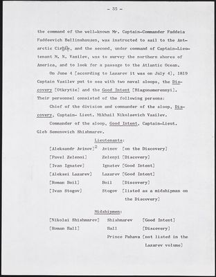
the command of the well-known Mr. Captain-Commander Faddeia Faddeevich Bellinshauzen, was instructed to sail to the Antarctic Circle, and the second, under command of Captain-Lieutenant M. N. Vasilev, was to survey the northern shores of America, and to look for a passage to the Atlantic Ocean.
On June 4 [according to Lazarev it was on July 4], 1819 Captain Vasilev put to sea with two naval sloops, the Discovery [Otkrytie] and the Good Intent [Blagonamerennyi]. Their personnel consisted of the following persons:
Chief of the division and commander of the sloop, Discovery, Captain- Lieut. Mikhail Nikolaevich Vasilev.
Commander of the sloop, Good Intent, Captain-Lieut. Gleb Semenovich Shishmarev.
| Lieutenants: | ||
|---|---|---|
| [Aleksandr Avinov]2 | Avinov | [on the Discovery] |
| [Pavel Zelenoi] | Zelenyi | [Discovery] |
| [Ivan Ignatev] | Ignatev | [Good Intent] |
| [Aleksei Lazarev] | Lazarev | [Good Intent] |
| [Roman Boil] | Boil | [Discovery |
| [Ivan Stogov] | Stogov | [listed as a midshipman on |
| the Discovery] |
| Midshipmen: | ||
|---|---|---|
| [Nikolai Shishmarev] | Shishmarev | [Good Intent] |
| [Roman Hall] | Hall | [Discovery] |
| Prince Pahava | [not listed in the | |
| Lazarev volume] |
mss142-vasilevShishmarev-i2-003
- 36 -
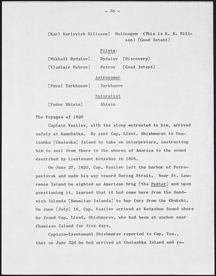
| [Karl Karlovich Hillesem] | Helinsgem | (This is K. K. Hill |
|---|---|---|
| sen) [Good Intent] |
| Pilots: | ||
|---|---|---|
| [Mikhail Rydalev] | Rydalev | [Discovery] |
| [Vladimir Petrov] | Petrov | [Good Intent] |
| Astronomer | ||
|---|---|---|
| [Pavel Tarkhanov] | Tarkhanov |
| Naturalist | ||
|---|---|---|
| [Fedor Shtein] | Shtein |
Captain Vasilev, with the sloop entrusted to him, arrived safely at Kamchatka. He sent Cap. Lieut. Shishmarev to Unalashka [Unalaska] Island to take on interpreters, instructing him to sail from there to the shores of America to the sound described by Lieutenant Kotzebue in 1816.
On June 27, 1820, Cap. Vasilev left the harbor of Petropavlovsk and made his way toward Bering Strait. Near St. Lawrence Island he sighted an American brig [the Pedler] and upon questioning it, learned that it had come here from the Sandwich Islands [Hawaiian Islands] to buy furs from the Chukchi. On June [July] 16, Cap. Vasilev arrived at Kotzebue Sound where he found Cap. Lieut. Shishmarev, who had been at anchor near Chamisso Island for five days.
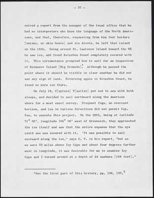
Captain-Lieutenant Shishmarev reported to Cap. Vas., that on June 32d he had arrived at Unalashka Island and re-
mss142-vasilevShishmarev-i2-004
- 37 -
ceived a report from the manager of the local office that he had no interpreters who knew the language of the North Americans, and that, therefore, requesting from him four baidars [umiaks, or skin boats] and six Aleuts, he left that island on the 19th. Going around St. Lawrence Island toward the NE he saw ice, and found Kotzebue Sound completely covered with it. This circumstance prompted him to sail for an inspection of Ratmanov Island [Big Diomede].* Although he passed the point where it should be visible in clear weather he did not see any sign of land. Returning again to Kotzebue Sound, he found no more ice there.
On July 18, C[aptain] V[asilev] put out to sea with both sloops, and decided to sail northward along the American shore for a most exact survey. Frequent fogs, an overcast horizon, and ice in various directions did not permit Cap. Vas. to execute this project. On the 29th, being at latitude 71[degree sign] 06', longitude 166[degree sign] 08' west of Greenwich, they approached the ice itself and saw that the entire expanse that the eye could see was covered with it. "It was possible to sail westward along the ice," says C. V. in his report. "but as we were 35 miles above Icy Cape and about four degrees farther west in longitude, it was desirable for me to examine Icy Cape and I turned around at a depth of 24 sazhens [168 feet]."
---------------------- *See the first part of this history, pp. 196, 197.3
mss142-vasilevShishmarev-i2-005
- 38 -
New obstacles did not permit Cap. Vas. to carry out this intention either, and therefore, he cruised southward on July 31. "Toward 8 o'clock in the morning," he continued, "we saw Cape Lisburne, and against it, ice toward the shore from the ENE to the NNE. The thermometer rose 2 1/2° [Réaumur]. I cannot say whether the ice, seen by us from Lisburne toward the north at the shore, was stationary." This observation of Cap. Vas. is very correct; the great [James] Cook said, says [Sir John] Barrow: "But C. cook observes, he dit not any part of this ice to be fixd; on the contrary, he considered the whole as a movable mas,"4 that is, Captain Cook noted, that in his opinion, all of the ice sighted by him was not stationary, but on the contrary, he considered all of it to be shifting.
All of the above-mentioned circumstances probably prompted Cap. Vasilev to leave the arctic regions. On this day, he said, "August 9 came out of the Arctic Ocean, was therein for 26 days. The shore was rather well explored from Cape Lisburne to Cape Krusenstern, except that we could not see Cape Mulgrave because of the haze. The American shore has no bays whatsoever. We did not see any rivers flowing into the sea. In some places water was seen beyond low-lying banks." This remark leads to the conclusion that the whole coast of America from Icy Cape to Cape Newenham consists of islands. The Honorable Davis concluded back in the year 1587 that the northern shores of America were formed of islands."5
mss142-vasilevShishmarev-i2-006
- 39 -
Here are the interesting remarks of C. V. about the northern shores of America. "The current of the sea was observed from NE to SW at about a half knot per hour, but near the shore it was swifter and changed direction. The declination of the compass was at its greatest, 35° 45' ,at latitude [?]6 but at Cape Lisburne, 35°." Remarkably, Cap. Cook, being at Cape Lisburne 42 years before Captain Vasilev (1778), had almost the same declination of the compass. At latitude 69° 57', longitude 193° 41', he found its declination 35° 32' east.
"At latitude 71° the declination of the magnetic needle was found to be 78° 30'. The Réaumur thermometer rose to about 11 1/2° and fell to 2 1/2° below freezing, but mostly it was 5° to 6° [43° to 45° Fahrenheit].7 Near shore, the depth of the ocean was sometimes found to be between five and seven sazhens [35 and 49 feet]. Being 80 miles west of the shores of America, we did not find the depth of the sea to be more than 30 sazhens. The land was completely bare. Here and there in the valleys moss showed itself, but standing timber was nowhere to be found. On the shores was seen a quantity of driftwood; the trees were very large poplars and fir [spruce] with roots." This remark about the forest and shallow depth near the ocean shores serves as indisputable evidence that there must be deep harbors and rivers flowing from the interior of the continent at various places on the continental shores of America between latitudes 70° and 65°,
mss142-vasilevShishmarev-i2-007
- 40 -
by means of which the mentioned driftwood is carried out to the seacoast. The above-mentioned sea current, from NE to SW, also serves as new and very strong evidence in confirming this conclusion.
"Above latitude 68° 30' we did not see any inhabitants. From afar, their drying racks look like masts with yards." Cap. Vasilev concludes, "We had no intercourse with the inhabitants because of the inconvenience at shore anchorages, bad weather at times, and not having interpreters."
From Cape Prince of Wales, Cap. Vasilev went to East Cape, and passing the Gvozdev Islands [Diomede Islands], set his course for St. Lawrence Bay [Gulf of Anadry], which was closed by ice. "This ice," he says, "must have been carried by the NE wind from the Arctic Sea. But one has to take into consideration that St. Lawrence Bay is still not free of ice." According to new infomation about the polar regions, and in considering the remarks of various travelers, one must conclude that arctic waters begin to be free of ice in the middle of August. The voyage of Cap. Parry serves as strong evidence to that. Among the journals of Captain Shmakva, at one time the commander of Izhiga, are found the answers of a Chukotski [Chukchi] chief to questions asked of him.
"The chief said when the Bering Strait becomes free of ice, then a multitude of whales, walruses, and seals go north and remain there until October and then return south. Therefore, it must be assumed that it is possible to sail in
mss142-vasilevShishmarev-i2-008
- 41 -
Bering Strait during the whole of September."
Coming into sight of St. Lawrence Island, Cap. Vasilev instructed Cap. Lieut. Shishmarev to finish surveying it, and he sailed toward the American shore. The gradual decrease in the depth of the sea from the eastern end of St. Lawrence Island was the reason that Cap. Vasilev turned west. and sailed toward the islands of [St.] Paul and [St.] George. Determining their geographic position, he continued his way to Unalashka and arrived there on August 19.
"Being in the Arctic Sea," says Cap. Vasilev, "I saw the necessity for a small sailing vessel, which could keep quite close to shore." On the sloop Good Intent there were parts of a disassembled boat in the hold. Therefore, Cap. Vasilev set his course from Unalashka to Novo-arkhagelsk port [NovoArkhangelsk, or Sitka] where there were more facilities than elsewhere to assemble that boat. He arrived there on September 15, and entrused Lieutenant Ignatev with the assembling of the mentioned boat, sailed from there on October 25.
Having spent the winter season in southern regions, Cap. Vasilev arrived in Sitka on May 13, 1821, at the port of NovoArkhangelsk. Finding that the boat was completely ready, he took on a reserve of water and wood,and receiving interpreters from the Chief Ruler of the American district, Fleet Cap. Lieut. Matveia Ivanovich Muravev, he put out to sea with all three vessels on May 30.
Taking in consideration that the newly assembled boat
mss142-vasilevShishmarev-i2-009
- 42 -
could not keep up with the sloops, Cap. Vasilev took it in tow, and continued on the way to the Aleutian chain. Upon approaching Unalashka, Cap. Vasilev entered the harbor in order to repair some damages.
Here Cap. Vasilev formed a new plan for the impending voyage in arctic waters. He instructed Cap. Lieut. Shishmarev, upon putting to sea, to proceed toward the northeastern shores of Asia and to look for a passage into the northern sea. In case of failure in that, he was instructed to survey the shore of Chukotski land [Chukchi Peninsula]. Cap Vasilev kept the boat for himself and intended to survey the shore of America between Bristol Bay and Norton Sound with it. After that, he planned to go to the Arctic Sea along the northwest coast of America and look for a passage into the Atlantic Ocean.
Vasilev's Voyage, 1821
On June 27th, Cap. Vasilev put to sea. The sloop Good Intent made its way to the shores of Asia, and the Discovery and the boat sailed towards [St.] Paul and [St.] George islands, and again verifying their geographic position sailed toward Cape Newenham, casing anchor on the southern side.
Here Cap. Vasilev appointed Lieut. Avinov commander of the boat, and giving him in assistance Midshipman Hall, son of the Honorable Vice-Admiral Roman Romanovich Hall, who had sailed those seas under the command of Cap. Billings in 1790 and 1791. Cap. Vasilev instructed Lieut. Avinov to survey
mss142-vasilevShishmarev-i2-010
- 43 -
the coast of America lying between Capes Newenham and Darby. He told him to join the sloop Discovery on July 20 at Stuart Island, but if Lieut. Avinov had not succeeded in finishing the survey of the mentioned shore by that time, he was permitted to remain there [at Stuart Island] until August 15, and if he did not meet Cap. Vasilev in Norton Sound then, to winter on Unalashka Island or at the harbor of Petropavlovsk.
On July 6, the boat went on its appointed way, and Cap. Vasilev, going at the same time to Cape Stephens, discovered, on the 11th, a coast not indicated on the maps. Coming to a depth of eight sazhens he cast anchor, and going ashore with the interpreters, was informed that they were standing off an island called Nunivok [Nunivak Island], located not far from the mainland coast of America, and which is inhabited, and that until now its inhabitants had had no contact whatsoever with Europeans. The latitude of the place of anchorage was 59° 54'; longitude, 193° 17' east of Greenwich. Cap. Vasilev named this island after the name of his sloop, Otkrytie [Discovery].
On June [July] 12, Cap. Vasilev weighed anchor, and directed his course to Norton Sound. Arriving at Cape Darby on the 19th, he remained there at anchor for 24 hours, and since Lieut. Avinov had not arrived with the boat, Cap. Vasilev sailed north. At latitudes 68° 01' and 68° 21' Cap. Vasilev sighted two noticeable capes, which Captains Cook and Clerke