Pages That Mention Washington
Coast Guard District narrative histories 1945
48
oil drum, the operator himself would pick up the drum and sinker and place it on station en route. Early in 1941, this was common practice as that section between The Dalles, Oregon and Umatilla, Oregon, was seriously handicapped by the lack of sufficient boat equipment. At the beginning of the war, an especially built 65' buoy boat was assigned to that area.
Experiments were made to determine the effectiveness of surface riding buoys, the first being with a Wallace and Tiernan and a 13th District boat type buoy, designed for the Columbia River. The buoys were placed on station in the Upper Columbia where the current was 8 miles per hour. The Wallace and Tiernan buoy was lost a month after its installation and a careful search of the river banks and dragging the river bottom failed to produce it or its mooring. Reports indicate that, until the time it disappeared, it had performed in an extremely satisfactory manner. The 13th District buoy was still in place at the conclusion of the war.
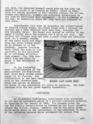
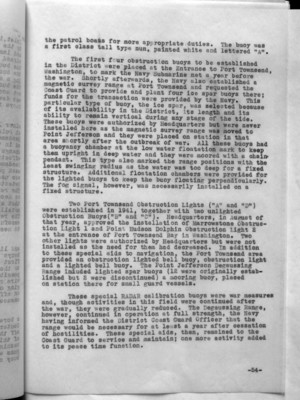
On the following page are photographs of the Headquarters pre-fabricated fast water buoy during assemblage and on station. The illustration of the boat type buoy is the District buoy which was placed on station and which at the conclusion was still in position. The Headquarters buoy did not prove equally successful.
(image) HOUSER FAST WATER BUOY
At Vancouver, Washington, Experiments were conducted in the use of Scotchlite, which is a plastic reflector material, on daymarks in the summer of 1943. Its success paved the way for similar installations on beacons in the Upper Columbia around The Dalles, Oregon. However, due to the heavy sands which stuck to the Scotchlite, it was abandoned in favor of the reflector buttons which protruded far enough from
-29-
53
Tests of the channel limiting group equipment were observed by the District Engineering and Marine Inspection Officers and it was their recommendation that it was worthwhile to establish and to put into use such an experimental range on the Columbia River. This was done at Arlington, Oregon, with Headquarters' approval, in the Spring of 1945. An investigation of the success of this type of range indicated that the majority of the operators preferred the old type regular center line lighted range of two boards. This preference, in the opinion of the District Coast Guard Office, was made primarily because of the lack of understanding and the use of the limiting channel range and, consequently, detailed printed instructions were issued to all operators in the Celilo-Pasco District where the Arlington range was located. As a result, more favorable comments were received in regard to the use of the limiting channel lights, but, notwithstanding, Headquarters would not authorize their establishment on other ranges where the two-board range was impracticable because of the terrain. This policy, which Headquarters adopted, left areas in the Columbia River unsafe for navigation as the lights and markings which could be established there provided only inadequate coverage.
INCREASE OF AIDS AND CHANNEL IMPROVEMENTS
Recommendations for the increase of aids to insure safety of mariners in the Upper Columbia were presented to the District Coast Guard Officer and Headquarters by the Board of Survey. Headquarters felt that complete justification for the project as a whole, as being vital to the war effort, had not been furnished, and requested that a complete list of all shipping interests concerned, the extent of their operations, and a list of all government agencies involved there in the war interest, be furnished. Letters from navigation companies indicating the large burdens placed on water carriers to transport the required petroleum products to Army and Navy installations on the Columbia were forwarded to Headquarters together with freight tonnages and traffic statistics. The proposed improvements were then approved and an appropriation of $50,000 was granted. (June, 1940). Additional appropriations were granted later.
The Snake River, which enters the Columbia just south of Pasco, Washington, was not navigable except during high water from the middle of March to the middle of July. At the time of the survey, the U. S. Army Engineers were contemplating the improvement of the Snake River by providing a
-33-
70
that an outage on any one of these buoys created a difficult situation and also because the necessity for an emergency blackout seemed extremely doubtful, this action seemed practicable. At the same time, it was requested that Headquarters postpone indefinitely the installation of the ANRAC equipment on buoys at the entrance of Willapa Bay and Grays Harbor as the equipment had not yet been placed on the buoys due to delay in installing the related control equipment on shore. This action, to remove ANRAC from Columbia River, Grays Harbor and Willapa Bay, was approved but the request for the installation of ANRAC on the five fog signals was not. Authority was granted, however, to equip Browns Point Light Station, newar Tacoma, Washington, as a control point for fog signals at Tacoma Waterway, Alki Point, near Seattle, Washington, as control station for Duwamish Head Fog Signal, Point No Point, Hansville, Washington, as control station for Double Bluff Lighted Trumpet Buoy and Point Adams, Hammond, Oregon, as control station for Desdemona Sands Fog Signal. A form No. 2609 for the installation at Duwamish Head was forwarded to Headquarters. No further action was taken by the District Coast Guard Officer on other points approved by Headquarters.
-50-
73
The Port Orchard Buoy No. 1, located in Sinclair Inlet, in Washington, was converted for RADAR calibration by the installation of special RADAR reflectors manufactured and installed by the Navy. These reflectors were so designed as to give a flat surface no matter in what position the buoy or ship might be. In order to limit the drift of the buoy, it was moored by three sinkers, each sinker having a mooring chain attached to a swivel at the bottom of the buoy. This arrangement cut down the normal drift to not more than five yards. This particular type of mooring was developed in the District to increase the stability of buoys for special stations.
In addition to the floating calibration units, three minor light structures were equipped with RADAR reflectors at Point Herron, Washington, Duwamish Head, Washington and Desdemona Sands, Oregon. These metal reflectors were mounted in the piling of the structure and therefore, did not change in the general appearance nor lessen the structures' effectiveness as aids to navigation. The installation at Desdemona Sands consisted of a metallic screen in two panels, each panel 8' by 8', forming an inverted "V". This screen was used for accurate orientation of the Army Service Craft Detector SCR-296 which was installed on Cape Disappointment. The reflector at Duwamish Head was requested by the Navy as necessary for five control RADAR calibration of ships in that area. The reflector there consisted of two cross metallic planes mounted on the piling underneath the lights. The reflector at Duwamish Head, Washington, proved most successful where a shore type reflector had previously failed to meet desired requirements.
In April, 1945, two of the three calibration targets and lighting equipment on the Blake Island RADAR calibration buoys were lost. The buoys were replaced by Coast Guard first class regular cans, equipped with 150mm lanterns. Due to the great depth of the water in that area, it was impossible to use chain as a mooring and consequently steel wire ropes were furnished by the Navy Yard for mooring. Dragging operations were carried out by Coast Guard tenders in an effort to recover the lost equipment, but the attempt was unsuccessful.
The last special purpose buoy to be installed, was a boresighting buoy requested by the Anti-Aircraft Training Center at Pacific Beach, Washington, and located 4,000 yards off the coast from the Station. Prior to the establishment of this buoy, a Coast Guard patrol craft from Grays Harbor, Washington, Had moored off the coast while the station's guns were being boresighted. The establishment of such a buoy not only facilitated the boresighting but also released
-53-
74
the patrol boats for more appropriate duties. The buoy was a first class tall type nun, painted white and lettered "A".
The first four obstruction buoys to be established in the District were placed at the Entrance to Port Townsend, Washington, to mark the Navy Submarine net a year before the war. Shortly afterwards, the Navy also established a magnetic survey range at Port Townsend and requested the Coast Guard to provide and plant four ice spar buoys there; funds for the transaction were provided by the Navy. This particular type of buoy, the ice spar, was selected because of its availability in the District, its length and its ability to remain vertical during any stage of the tide. These buoys were authorized by Headquarters but were never installed here as the magnetic survey range was moved to Point Jefferson and they were placed on station in that area shortly after the outbreak of the war. All these buoys had a buoyancy chamber at the low water flotation mark to keep them upright in deep water and they were moored with a chain pendant. This type also marked the range positions with the least swinging radius as the water was too deep for a fixed structure. Additional flotation chambers were provided for the lighted buoys to keep the buoy floating perpendicularly. The fog signal, however, was necessarily installed on a fixed structure.
Two Port Townsend Obstruction Lights ("A" and "D") were established in 1941, together with two unlighted Obstruction Buoys ("B" and "C"). Headquarters, in August of that year, approved the installation of Marrowstone Obstruction Light 1 and Point Hudson Dolphin Obstruction Light 2 at the entrance of Port Townsend Bay in Washington. Two other lights were authorized by Headquarters but were not installed as the need for them had decreased. In addition to these special aids to navigation, the Port Townsend area provided an obstruction lighted bell buoy, obstruction light and a lighted bell buoy. The Point Jefferson Degaussing Range included lighted spar buoys (12 were originally established but 2 were discontinued) a mooring buoy, placed on station there for small guard vessels.
These special RADAR calibration buoys were war measures and, though activities in this field were continued after the war, they were gradually reduced. The Degaussing Range, however, continued in operation at full strength, the Navy having informed the District Coast Guard Officer that the range would be necessary for at least a year after cessation of hostilities. These special aids, then, remained to the Coast Guard to service and maintain; one more activity added to its peace time function.
-54-