Pages That Mention Yaquina Head
p-1 1881 YH Descriptive Pamphlet
4
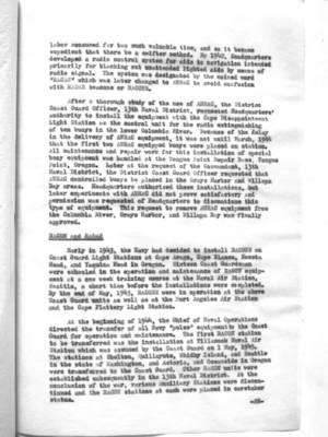
1 NAME AND POSITION OF THE LIGHT-HOUSE AND LIGHT-STATION. Cape Foulweather, on the westerly end of Cape Foulweather (Yaquina Head) Oregon
By whom described. G.L. Gillespie Major of Engineers Light-House Engineer 13th District
Date of description, July 1881
Distinguishing Character of light or lights. Fixed White Latitude of tower. 44.43. (30) Authority Light-House Longitude of tower, 124.05. (00) List of 1881
PREMISES- A DETAILED DESCRIPTION OF, EMBRACING—
Area of the entire site. 30 acres 17.86
Character of surface soil. Dark Clayey loam
Distance of tower from nearest high-water mark. Two hundred and fifty feet.
Enclosure to premises. The entire site is enclosed by a fence running across the point of the cape from the South to the North shore. The keepers dwelling is enclosed by a neat picket fence.
Wharf or Landing on premises. No wharf or landing on premises. A landing can be made with a boat, on the beach in smooth weather, but is usually dangerous.
Road to landing or wharf, character of, and distance from tower. One fourth of a mile. No road, trail leads down the steep bluff to the beach.
Means by which the light-station may be reached. By railroad to “Corvallis”, eighty miles, thence by stage to Newport sixty (60) miles to the Light House.
Coast Guard District narrative histories 1945
11
labor consumed far too much valuable time, and so it became expedient that there be a swifter method. By 1942, Headquarters developed a radio control system for aids to navigation intended primarily for blacking out unattended lighted aids by means of radio signal. The system was designated by the coined word "RACAN" which was later changed to ANRAC to avoid confusion with RADAR beacons or RACONS.
After a thorough study of the use of ANRAC, the District Coast Guard Officer, 13th Naval District, requested Headquarters' authority to install the equipment with the Cape Disappointment Light Station as the control unit for the radio extinguishing of ten buoys in the lower Columbia River. Because of the delay in the delivery of ANRAC equipment, it was not until March, 1944 that the first two ANRAC equipped buoys were placed on station. All maintenance and repair work for this installation of special buoy equipment was handled at the Tongue Point Repair Base, Tongue Point, Oregon. Later at the request of the Commandant, 13th Naval District, the District Coast Guard Officer requested that ANRAC controlled buoys be placed in the Grays Harbor and Willapa Bay areas. Headquarters authorized these installations, but later experiments with ANRAC did not prove satisfactory and permission was requested of Headquarters to discontinue this type of equipment. This request to remove ANRAC equipment from the Columbia River, Grays Harbor, and Willapa Bay was finally approved.
Early in 1943, the Navy had decided to install RACONS on Coast Guard Light Stations at Cape Arago, Cape Blanco, Heceta Head, and Yaquina Head in Oregon. Sixteen Coast Guardsmen were schooled in the operation and maintenance of RACON equipment at a one week training course at the Naval Air Station, Seattle, a short time before the installations were completed. By the end of May, 1943, RACONS were in operation at the above Coast Guard units as well as at the Port Angeles Air Station and the Cape Flattery Light Station.
At the beginning of 1944, the Chief of Naval Operations directed the transfer of all Navy "pulse" equipment to the Coast Guard for operation and maintenance. The first RACON station to be transferred was the installation at Tillamook Naval Air Station which was assumed by the Coast Guard on 1 May, 1945. The stations at Shelton, Quillayute, Whidby Island, and Seattle in the state of Washington, and Astoria, and Oceanside in Oregon were transferred to the Coast Guard. Other RACON units were established subsequently in the 13th Naval District. At the conclusion of the war, various Auxiliary Stations were discontinued and the RACON stations at each were placed in caretaker status.
-28-
12
It was the intention of the Coast Guard to make the most possible use of RADAR and other electronics devices in order to increase the efficiency of its public services. One shore base installation was established and two installations were tentatively scheduled to be used as an experimental setup to determine whether necessary coverage could be provided for air-sea rescue operation.
The District Coast Guard Officer of each District was directed to investigate the possible application of shore based RADAR to the particular problems of his district. Consideration was given to the need of air-sea rescue to provide warning of potential or real distress, to determine the assistance to possible control of shipping in and around harbors and the use of RADAR as a supplementary aid for coastal lookout as well as in checking the position of navigational or any other applications which would increase the efficiency of Coast Guard functions. Results of these investigations by the District Coast Guard Officer were submitted to Headquarters in order that no phase of application be overlooked in the overall study.
The end of the war found the District not only operating fourteen RACON stations but a new electronic aid, LORAN, with stations at Cape Blanco, Oregon; Point Grenville, Washington; and Spring Island, Vancouver, B. C. A Monitor Station for LORAN had been set up at Yaquina Head, Oregon. Installation and supervision of LORAN was controlled entirely by Headquarters. However, on survey trips to determine sites for the various stations, representatives of the District Coast Guard Officer, 13th Naval District, had been present. The original installations at the aforementioned stations were temporary, in that they were mobile units, contracts having been let to private industry for the construction of permanent stations. The Aids to Navigation Office distributed 1500 temporary LORAN navigation charts covering the coast from Cape Blanco to Spring Island to Army, Navy, and Canadian Air Stations, as well as to innumerable warships.
CAMOUFLAGE OF LIGHT STATIONS
Early in the war, the Commandant, 13th Naval District, ordered the concealment of painting of ten of the Light Stations that were near military areas or war industries. The walls were "toned down" with gray and the space under the eaves painted black to accentuate the silouette of the station as it appeared from the water. (Tongue Point Repair Base was provided with a camouflage net to cover the wharves where vari-colored buoys and markers were stored. This base was in the vicinity of the Naval Air Station, Astoris, and the work was done in conjunction with assistance from that activity). Army activities near Coast Guard
-29-
27
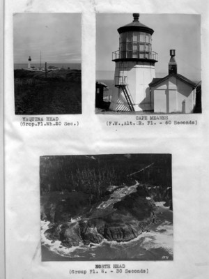
(Image top left)
YAQUINA HEAD (Grop.Fl.Wh.20 Sec.)
(Image top right)
CAPE MEARES (F.W.,Alt. R. Fl. - 60 Seconds)
(Image bottom)
NORTH HEAD (Group Fl. W. - 30 Seconds)
38
An arrangement was made for rating the radiobeacons on a percentage basis for efficiency of operation. For each various type of failure, an established number of points were deducted from a perfect score. These scores were then arranged in chronological order and published each month. However, a discrepancy was evident in that one station operating on the wrong minute for 35 minutes received the same percentage rating as a station being off sequence for only 10 minutes. A new plan for such rating was established and put into operation in the early part of 1945. This new system was so arranged that an offending radiobeacon station was marked down for not only the type of failure, but for the number of minutes of faulty operation. This accounted for the low percentage rating for 1945 of 94% as compared with the percentage rating of 96% for 1943 and 98% for 1944. Actually, the number of failures occurring after the February survey (see survey below) in 1945 became less than those in the months prior to that date.
The Radiobeacon Station guilty of the most failures was on the Columbia River Station. The high percentage of failures in this case was due to a combination of old equipment, fluctuating voltage, disinterested personnel, too small a complement and the motion of the ship, which tended to dislodge the sensitive parts, especially during heavy seas. Little or no interference was found in any of the radiobeacons. One instance of expeditious conduct occurred at Yaquina Head Radiobeacon Station when lightning struck the building in which the beacon was housed and destroyed the equipment and severely injured the operator on watch. Only twelve (12) minutes elapsed between the time the radiobeacon was struck and put out of commission before the standby unit was operating normally.
Peace time operation of the radiobeacon consisted of the distance finding dash being sounded when fog was actually in the area of the radiobeacon and the fog signal was in operation. During the war, the distance finding dash was used continuously as for fog for the purpose of not allowing the enemy to know whether it was foggy or clear weather. Two days after the declaration of war, on 9 December, 1941, the radiobeacon stations were instructed that no radiobeacon signals and no test transmissions in the radiobeacon band were to be permitted during the emergency without specific authorization from the District Coast Guard Officer. This order permitted no variation and forbade all radio frequencies radiation within the band from 285 to 315 kcs. from any radiobeacon stations. Radiobeacon transmitters on any frequency