Pages That Mention Destruction Island
Box 247 1899 to 1900 JA land 4000 app 1866 reserved
7
All communications should be addressed to "The Light-House Board."
Treasury Department Office of the Light-House Board Washington, March 13, 1900
Nine enclosures.
Capt. W.C. Langfitt, U.S.A., Engineer 13th Light-House District, Portland, Oreg.
Sir:
Referring to your letter of 18 Oct., '99, the Board transmits herewith, for your information, and for the files of your office, copies of the executive orders of the President reserving public lands for light-house purposes in the 13th Light-House District, at the following named places: --
Umpqua, Oreg., reserved by executive order of 27 Dec., '59. Tatugh Point on Blake Island, Wash., reserved by executive order of 25 March, '69. Cape Johnson, Wash., reserved by executive order of 8 June, '66. Destruction Island, Wash., reserved by executive order of 8 June, '66. Cape Foulweather, Oreg., reserved by executive order of 8 June, '66.
Coast Guard District narrative histories 1945
8
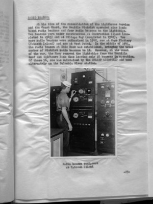
At the time of the consolidation of the Lighthouse Service and the Coast Guard, the Seattle District operated nine land-based radio beacons and four radio beacons on the lightships. Two beacons were under construction at Destruction Island (completed in 1943) and at Willapa Bay (completed in 1941). Two more radio beacons were authorized in 1942, one at Cape Flattery (Tatoosh Island) and one at West Point. In the middle of 1945, the radio beacon at Ediz Hook was established, bringing the total number of District radio beacons to 18. However, at the onset of the war, the Navy removed the lightships from the Umatilla Reef and Swiftsure Bank thus leaving only 16 beacons in operation. Of these 16, one was maintained by the RELIEF LIGHTSHIP and used alternatively on the Columbia River station.
(Photo inserted here)
Radio beacon equipment at Tatoosh Island
-25-
21
In the quite rapid succession, Umpqua River, Willapa Bay, Smith Island, Ediz Hook, Cape Arago, Cape Blanco, Point No Point, Point Wilson, and Yaquina Bay Lighthouses were built. In 1879, construction began on the Tillamook Rock Beacon.
Tillamook Rock Lighthouse was one of the most famous as well as one of the most exposed stations in the Lighthouse Service, set on a great precipitous rock lying a mile offshore from Tillamook Head on the Oregon Coast. A dark cloud of ill omen shadowed the station as, in the landing of the construction party, the superintendent was swept by a great wave into the sea and drowned. Almost insurmountable obstacles faced the engineers, for the entire top of the rock mass had to be blasted level to provide space for the lighthouse and its accompanying structures. Heavy seas continually washed over the Rock carrying away half finished foundations, equipment and endangering the lives of the entire work party. Although the light stood 133 feet above the water, on many occasions tremendous waves swept completely over the station carrying large fragments of rock which caused considerable damage to the station. On one such occasion, a rock weighting 135 pounds was hurled through the roof of the building and into the quarters below, causing extensive damage. Another time, the sea tossed a boulder through the lantern, extinguished the light and flooded the dwelling below.
West Point, built in 1881, Alki Point and Brown Point, built in 1887 and Destruction Island, built in 1891, were the next light stations to be erected. Here again, at Destruction Island, treacherous seas made landings difficult except in calm weather, so the "basket" and boom were again called upon for safe landings on the station. 14 other lighthouses were established in the Seattle District, the last being the Lim Kiln structure in 1914. Strangely enough, the Lime Kiln Lighthouse was the last light station in the District operating an oil lantern. An attempt was made to electrify the light by extending commercial power to the Station but the Power Company was unable to furnish sufficient current; in the same regard, poles had to be set in a solid rock and the cost and labor for this were almost prohibitive. A request was made for Headquarters' approval to install a power plant at the unit but this was not commensurate with Headquarters' policy so the light remained an incandescent oil vapor type. This type, familiarly known as i.o.v., gave good service although its range could not match that of the newer electric light. The old i.o.v. light came in two sizes and was approximately equivalent
-2-
22
to the 350 watt and 750 watt electric lamps of today; this limitation permitted slight variation in the range of the lighted beacons. The lenses increased and magnified the light as they revolved to produce a flashing effect.
Reminicenses of the Lighthouse men who tended these lights during the years when the Northwest was, for the most part, a mountainous wilderness, make interesting listening. Even after the invention of railroads, telephones and the automobile, trips to coastal Light Stations involved travel by boat, stage and horseback. Stage drivers informed passengers before the journey began, that there was no guarantee that the stage could complete the trip, in which event, the traveller made the remainder of his journey on foot. Seasonal rains, washouts, and the miserable conditions of the "roads" (deer trails, or Indian paths) made such stipulations a necessity. Today's brief trip from Bandon to Cape Blanco, Oregon, can be made either way in a fraction of an hour; earlier travellers spent three days; The uncertainty of transportation was illustrated in the following anecdote: An engineer of the Lighthouse Service was called to Destruction Island to repair the boilers. A buoy tender took the engineer to the Island and he requested that the tender return on Friday to pick him up. Friday came - and went; another Friday - no tender; a third Friday - and in the distance the curl of a tender's smoke was seen on the horizon (in those days the smoke trails of the various type ships identified them to the men whose idle hours were spent watching the horizon for the vessels that occasionally appeared there.) When the Master of the tender was admonished for his tardiness, he replied, "You said to come on Friday; isn't this Friday?". Time was of little import.
Life on the Light Stations until the middle thirties was a world of its own. Because of their locations there were no telephone facilities, and commercial electric power did not reach to the outposts. There were generally two keepers and their families assigned to each station and the competition for the most tidy and efficient station among the keepers was keen. A few of the isolated stations at Tillamook Rock, Destruction Island, Cape Flattery, etc. had four or five keepers, one on continuous liberty rotation. With the installation of radiobeacons at many of the stations, it became necessary to bring in commercial electric power or generate power at the station. With electricity available, the i.c.v. light was superceded, the fog signals mechanized, and the comforts of the keeper's dwellings increased. Telephone service or radio-telephone service soon followed as
37
The early conception of the mariners, that all aids to navigation must be received by the normal senses of sight and sound, was radically changed by the development of the radiobeacon system which has, since its inception in 1921, become recognized as a most important innovation for increased safety for mariners. As radio signals are not obscured by fog, wind, rain, snow or temperature changes, and bearings may be taken at great distances far beyond the horizon, the radiobeacon had great advantages over previous types of navigational aids. Proof of its efficiency lay in the fact that since its inception approximately a quarter of a century ago, the radiobeacon system was adopted by all maritime nations and direction finders were developed to fit not only the requirements of large ocean liners, but small pleasure craft and fisherman's vessels as well.
At the time of the consolidation of the Lighthouse Service and the Coast Guard, the Seattle District operated nine-land-based radiobeacons and four radiobeacons on the lightships at Swiftsure Bank, Umatilla Reef and the entrance to the Columbia River. Two beacons were under construction at Destruction Island (completed in 1943) and at Willapa Bay (completed in 1941). Two more radiobeacons were authorized in 1842, one at Cape Flattery (Tatoosh Island) and one at West Point. In the middle of 1945, the radiobeacon at Ediz Hook was established, bringing the total number of District radiobeacons to 18. However, at the onset of the war, the Navy removed the lightships from Umatilla Reef and Swiftsure Bank thus leaving only 16 beacons in operation. Of these 16, one was maintained by the RELIEF LIGHTSHIP and used alternately on the Columbia River station.
In an effort to increase, to even a greater degree, the efficiency of the radiobeacon system throughout the United States, headquarters urged that a monitor system be developed and put into operation in each District. Subsequently, a monitor station was established at North head Radio Station which checked the performance of all District radiobeacons. Between 0800 to 1100 and 1500 to 1900 daily, each radiobeacon was monitored, the time for the check being staggered to insure a truer picture of the various beacons' performance. Outlying stations were notified daily of all failures or defects in the radiobeacons' operation. These reports were a District innovation and were not required by Headquarters but were merely another measure adopted by the District Coast Guard Office for increased efficiency in the District system.
-18-