Pages That Mention Coos Bay
Box 251 YB YH reprimand stove 1874 to 1875
15
Buoyage Coos Bay & Yaquina Bay
Renewal of agreement for
Dec. 5th 79
Sir:
Referring to your letter of Nov. 24th, asking directions relative to the renewal of the agreement for the care of the buoys in Coos Bay and Yaquina Bay, I have to say that the Board desires you to make the best terms you can for the care of these buoys for the present.
It is believed that the tender Shubrick will be permanently assigned to the 13th L.H. District early in Feb'y, and that she will be able to attend to the buoyage of the entire district.
Very respectfully, Geo. Dewey Commander, U.S.N. Naval Secretary
Lieut. G.C. Reiter U.S.N. Inspector 13th LH District Portland, Oregon
Coast Guard District narrative histories 1945
42
Causes of radiobeacon failures were generally easily repairs, but it was the duration of these failures which the District Coast Guard Office worked incessantly to overcome. Monitor stations experienced great difficulty, at times, in notifying an offending station of its inoperation due to the frequent inability to make radio contact with the radiobeacon station which necessitated routing the message through other stations or agencies. Heavy storms in the area destroyed telephone communication and on occasion, visual signals had to be relayed to certain stations. Alarm units, as noted above, were not perfected, so frequently radiobeacon stations were unaware of their defective operation until notified by the Monitor Station. Had there been some means for notifying, under all conditions, the radiobeacon station of its faulty operation immediately after the failure was detected, the duration of faulty operation would have been greatly reduced.
Although the radiobeacons in this District were not operating at 100% efficiency, it was the opinion of the District Office that the beacons were operating on a par with beacons throughout the continental United States. This was determined by the reports from mariners and airmen who used beacons as navigational aids and was also due to the determination of the Aids to Navigation Officer to increase the efficiency of the beacons.
A radiobeacon buoy with a working range from 7 to 50 miles had been developed and was considered in the 13th Naval District the year before the war. Trials were made on batteries in some of the rough waters along the coast and on the Columbia River Bar. The batteries proved too fragile so dry packs were tested; these, too, developed defects. As the packs cost $40.00 a piece, much experimentation proved too costly. The District Coast Guard Officer saw the advantage of a perfected radiobeacon buoy in that a string of such buoys along the coast, 15 to 20 miles apart on the 30 fathom curve, would eliminate the necessity of the UMATILLA REEF LIGHTSHIP; the removal of the Lightship would counteract the use of tenders servicing the equipment (buoys had to be serviced every 4 months), as well as the cost. The Aids to Navigation Officer and the District Coast Guard Officer were both in favor of the establishment of a radiobeacon buoy at Grays Harbor Entrance where there had been considerable agitation for a Lightship; this station was within easy run for the CGC MANZANITA. Had the buoy proved applicable to conditions at Grays Harbor, buoys could have easily been installed at Duntze Rock, Yaquina Bay, Tillamook Rock, Umpqua, Coos Bay and Wherever tender equipment was available.
-23-
50
the daymark to prevent their whole surface from being filmed with sand and dust. The Scotchlite was installed in other District Areas, mainly Coos Bay, with hearty approval of the mariners in the Bay.
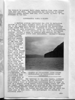
A serious problem confronted the Aids to Navigation Section in the Upper Columbia where it was impracticable, due to the impossible terrain to establish the conventional range lights but where it was necessary to provide channel markings for safe navigation. After two years, consideration, C. E. Sherman, Nautical Scientist of the Aids to Navigation Section, devised a means to provide this marking and the initial experiment proved most successful. Sherman's "channel limiting group" lights provided positive protection for a width of 198 feet and were so arranged that the center light showed flashing red and the lights on either side showed fixed white until the navigator departed from his course and reached the edge of the safe channel, at which time the white light marking the channel side became red. Should he continue into the red light, it appeared to be extinguished, which indicated a deep penetration into the outer side of the safe channel. The openings in the side lights, although but 1/8" wide, could be seen for a distance of 1.4 statute miles with a light of sufficient brilliance that it could be seen by a person having normal vision looking within 30° from the light. These openings were provided by the arrangement of two opaque screens spaced 10 feet apart along the axis line of the light, one having its left edge and the other its right edge on this axis. (See photographs and sketch on following page.)
(image) EXAMPLE OF PRECIPITOUS SHORE MAKING INSTALLATION OF CONVENTIONAL RANGE IMPOSSIBLE
-30-