Pages That Mention tender
Coast Guard District narrative histories 1945
47
(picture)
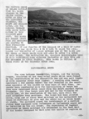
THE PICTURE SHOWS AN INLAND NAVIGATION CO. BARGE ST(R)ANDED IN THE CELILO RAPIDS, GIVES AN IDEA OF THE DIFFICULT CHANNELS, THE SWIFT AND SHALLOW WATER, AND THE GENERAL TERRAIN WITH WHICH NAVIGATORS IN THIS VICINITY MUST COPY. THE BARGE HAD BROKEN LOOSE FROM ITS MOORINGS AND DRIFTED TO THIS PRECARIOUS POSITION. IT WAS FLOATED BY THE RELEASE OF A HEAD OF WATER FROM COULEE DAM WHICH TOOK 2 TO 3 DAYS TO REACH THE AREA. RESCUE WAS CONDUCTED BY CABLES BETWEEN MEN ON THE BARGE AND THE SHORE AS POWER BOATS WERE NOT ABLE TO ENTER THE RIVER AT THIS POINT. THE NAVIGATION CO. REALIZED CONSIDERABLE LOSS IN THIS PARTICULAR CASE ALTHOUGH INSTANCES OF THIS TYPE ARE NOT UNCOMMON IN RIVER TRAFFIC. THIS BARGE IS TYPICAL OF THOSE FOUND IN THE COLUMBIA RIVER AREA.
EXPERIMENTAL BUOYS
The area between Bonneville, Oregon, and The Dalles, Oregon, consisted of two deep water pools which were formed by the construction of the Bonneville Dam and was well lighted with numerous river bank lights. a meeting with vessel operators a few months before the war resulted in the unanimous approval of the lights as they were at that time. Requests were constantly made for installation of buoys but none were developed which could ride the swift current during freshets. Oil drum buoys were set out in the vicinity of Celilo and, at the conclusion of the war, were still the most effective buoy markings. The buoys had been painted white, with red or black band markings as the navigators had found it difficult to pick out the solid red or black buoys at night. The mariners urged the development of a surface riding buoy equipped with reflectors as reflectors could not be installed on the oil drums. The dependency of tugboat operators on these markings was evidenced in the fact that if the tender assigned to that area was unable to replace an
_28-
55
miles from Mason City to the Canadian border. A question arose as to whether or not Roosevelt Lake constituted part of "the navigable waters of the United States" as interpreted by the laws. In March, 1944, the Law Officer advised that Roosevelt Lake was navigable and, together with the Columbia River which flows into it and gives rise to it, furnished a water way for foreign commerce. With this fact established, it became necessary to establish aids to navigation along the lengths of this lake. At that time, there was very little traffic on Roosevelt Reservoir but it was the opinion of local marine interests that the traffic was bound to increase not only commercially but in pleasure craft following the war. Numerous hazards existed that made travel especially dangers under the conditions as they then existed. In a meeting between the Superintendent of the Coulee Dam and representatives of the District Coast Guard Officer, location were proposed for spar buoys to be anchored in the lake and provide the shortest run from Grand Coulee Dam to Kettle Falls, Washington. These locations were consistent with assumed limitations of 20 feet of water at buoy locations with a maximum reservoir drawdown at elevation 1208 and a minimum distance between the buoys 1/2 mile; the normal elevation of the reservoir when full is 1290. An investigation made by the Aids to Navigation Officer determined that 27 lights and 10 reflectors would suffice to mark the lake. The Bureau of Reclamation was in favor of the establishment of 51 buoys but the District Coast Guard Officer felt that buoys would be impracticable for several reasons. Due to the lowering of the water to different levels which would cause different shoal areas to appear and changes would have to be made in the buoys to keep the channel safely and effectively marked. Furthermore, the mountainous land area which formed the bottom of the lake together with the deep water, rendered use of buoys inadvisable; for in many places the buoys would be moored in over 200 feet of water which would require large buoys and, consequently, the services of a buoy tender. Unlighted buoys were not considered, for, as such, they would be inadequate. For these reasons then the Aids to Navigation Officer determined that the 27 lights and 10 reflectors would be adequate. These lighted aids would consist of a battery box on a concrete foundation with a 200mm lantern with a focal plane of 12 feet. Aids were to display a white light of 90 candlepower, flashing either every 4 seconds, 6 seconds or 10 seconds, and were to be serviced by the Seattle Operating Base twice a year with half of the batter cells being relieved at a time. The Bureau of Reclamation extended the use of one of its boats to be used in establishing these aids and in the servicing of them.
-35-
103
Prior to, and for almost a year following, the consolidation of the Lighthouse Service and the Coast Guard, the Aids to Navigation Section was administered by an Associate Mechanical Engineer with the assistance of two clerks and a stenographer. Both operational and engineering activities were combined in this section until the District was reorganized according to the Coast Guard organizational plan. Engineering duties were then delegated to a separate Engineering Section and the operation and maintenance of aids to navigation became the responsibility of the Section. The Associate Mechanical Engineer, later promoted to Nautical Scientist, administered the department until the assignment of an Aids to Navigation Officer in 1944. Until that time, however, the staff had increased to two Coast Guard Officers (R) (male) and one SPAR Officer, 3 enlisted Coast Guardsmen and 6 enlisted SPARS. in 1945, An Assistant Aids to Navigation Officer, trained especially in electronic Aids, was assigned to the Section.
Although particular duties were delegated to certain desks, an attempt was made to instruct all personnel in the overall working of the department so that in the event of transfer, leave, discharge, or illness, there was no obvious vacancy that required complete training to handle. Supervision of filing, typists, records and all clerical work was done by a SPAR Yeoman, 1st class. Field trips were made by the Associate Mechanical Engineer and the male officers to inspect aids, prepare forms 2609, for proposed projects, investigate new sites, confer with Pilots' Associations and, in conjunction with the Engineering Section, to determine the requirements of new aids. All tender orders were issued from this Section and the reports of tenders' activities were kept on file. The SPAR Officer was instructed in non-technical operation of RADAR Beacons and Radiobeacons and was, in addition to her duties in the Section, also a Hydrographic Officer for the compilation of the Arctic Ocean, Bering Sea and Aleutian Coast Pilot for the District Coast Guard Officer.
The filing system, as developed in the department, consisted of a rough running log kept weekly and transferred to a smooth log under another cover at the end of each week. All correspondence was logged under its correspondent (to or from) and also its subject. File numbers were assigned and folder designations were made from an Office Index. Pieces of correspondence, filed since the origin of the system in 1943, had passed the 15,000 mark by the end of September, 1945. Folders numbered to 730 with a transfer file of several -83
Correspondence of LH board 1901-1910
15
Yaquina Head Light-Station Newport Oregon Aug 31st 1907. ATJ. Copy. File No.
P.J. Werlick Commander U.S.N., Light House Inspector Thirteenth District Portland Oregon
Sir I hereby tender my resignation as Keeper of Yaquina Head Light Station to take effect September 30th 1907. Very Respectfully Frank M. Plummer Keeper Yaquina Head Light-Station