Description
USC22_0004
In his Queensland geological map of 1892, R. L. Jack unfortunately placed the whole of Fraser Island in the lower Trias-Jura System of the Mesozoic, the same as he assigned to the Burrum coal beds, and yet there is no the slightest resemblance between the two localities. Geologically and botanically, Fraser's Island, incredible as it may appear, stands apart from the whole of the Australian continent!
USC91_0004
1.1.3. Natural and protected "wallum" areas adjoining the above: Protected mainland areas including Woodgate, Burrum Heads, the proposed Kinkuna Boonooroo Plains and Kauri Creek National Parks, Mon Repos Environmental Park and the Wide Bay Military Training Area.
---
1.1.4. Protected estuarine areas adjoining Hervey Bay, Great Sandy Strait and Tin Can Bay: The Burrum River, Beelbi Creek and Susan River Fisheries Habitat Reserves.
USC281_0008
THE ABORIGINES
Fraser Island is believe to have supported between 2,000 and 3,000 aborigines in 1850. They were all members of the Kabi nation whose territory extended over the whole of the Mary, Burrum, Noosa, Maroochy and Mooloolah River basins. The Kabi nation was divided into 19 sub tribes or clans, each with its own tribal lands with clearly defined boudaries. The Butchulla tribe is reported to have occupied Fraser Island.
Related Subjects
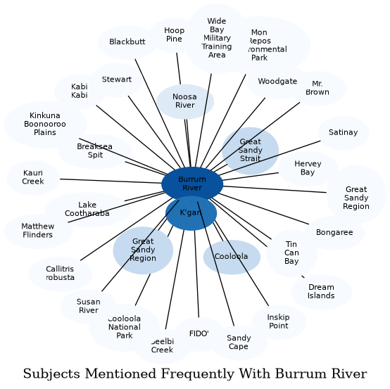
The graph displays the other subjects mentioned on the same pages as the subject "Burrum River". If the same subject occurs on a page with "Burrum River" more than once, it appears closer to "Burrum River" on the graph, and is colored in a darker shade. The closer a subject is to the center, the more "related" the subjects are.