Pages
(seq. 6)
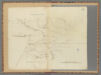
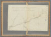
Scale 6 miles to an inch
Tawa River; Head-Waters of Au Glaize; St Mary's River; Fort Adams 1794 a deposit; Girty's Town; Main branch of the Wabash River; Fort Recovery 1794; Battle between General St Clair & the Indians November 4, 1791.; Lorimie's Store; Great Miami River; Still water creek; Grenville Creek; Branch of Great Miami River; Fort Grenville 1794; Treaty 1795; Fort Jefferson 1791. Observed Latitude 40 degrees 4 minutes; Road to Fort Washington; Indian Boundary line 1795; Indian boundary line 1795;
(seq. 7)
from the {Reverand} Dr Belknap; Secretary to the Historical Society.; 1796.
(seq. 9)
The red pricked lines show the route of the army of the United States under the Command of General Wayne during the Campaign of 1794; Encampments.; h Indian Villages; The red squares denote the cessions of Territory, without beyond the Indian boundary, made by the Treaty of 1795.
The army consisted of a Legion of regular troops & a detachment of Kentucky Militia. in all about 3000.
Branch of the Wabash River; Fort Wayne 1794; Portage 8 miles; Miami Village; St Joseph's River; Grand Glaize River; Fort Defiance 1794; Bean Creek; Little Turtle Indian Village; Blue jacket Indian Village; River Miami of the Lake; Rapids of the Miami River; Roche de bout; Turkey foot Creek; McKee's Store; British fort; Battle between the Army of the United States under General Wayne & the Indians August 20, 1794.; Swan creek; Indian encampment before & after the action of August 20, 1794.; Cedar Island; Lake Erie