Pages
(seq. 1)
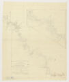
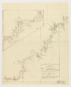
A Chart of Part of the Country of LABRADOR Taken by Order of Commodore Shuldham in a Tour up the Coast in the Year 1773. by Lieutenant Roger Curtis.
N.B. The pricked line denotes Mr Curtis's track up the Coast, but the same passage must not be attempted by a Ship of burden.
Ikenelake; {Cape} Bluff; Webatuke; {Cape} Columbus; Ectrawbiuk; Kyemuckcemick; x x; Low Lands towards the Sea; x x; Noobootaleweet.; Cape Cod; Netshucktoke; Low Lands towards the Sea; Innuikchuckluck.; IVUKTOKE Inlet 30 Leagues.; Okehowtet; Ockpaseeguock; Byron's Bay.; Cannotocktuit; Kyucktabuck.; Moggounok; x; Caluileweet.; Kypocock; CANYKETOKE.; Inlet 15 Leagues; Cannuckthowatooktuock; Nowyockshuockshook.; Inlet 20 Leagues.; OGBUCKTOKE; Tickithockthuock.; Nannucktoot.; Davis's Inlet 18 Leagues.; 53°; 54°; 55°; 56°;
Davis's Inlet 18 Leagues.; 20; NAIN; Nain; Unity Bay; Pownalls {Island}; Hillsborough {Island}; Owlichivick; Kiglapyeet; Keewedloke; 57°; 58°