Pages
Not Started
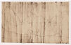
(seq. 1)
This page is not transcribed, please help transcribe this page
Complete
Indexed
(seq. 3)
Photograph of the map showing the line between New York and New Jersey, as seen by Commissioners 1769; -; The original map is in this Library, and was lent to the Regents of the
Indexed
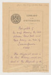
(seq. 4)
University of New York to be photographed.; Justin [Winsor?]; February 20 1884; [mark?]
Indexed
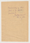
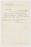
(seq. 5)
State Library; Department of Historical Records; Albany, New York; February 19, 1884; Dear Sir,; I send you herewith under separate cover the promised photographic copy of Razter's map of the N.Y. and N.J. boundary line of 1769.; [ J. Winsor ?] Esq.; Very truly yours,; B Fernow