Pages
PB01P200
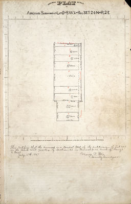
ASSESSORS SUBDIVISION OF LOT 9 IN S. W. ¼ OF SEC. 33. T24 N OF R. 2 E
This certifies that the annexed is a correct plat of the subdivision of Lot No 9 in the south west quarter of section 33 in Township 24 north of Range 2 East
July 15th 1867
George P. Ela County Surveyor.
PB01P201
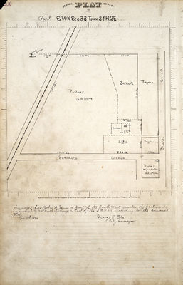
PART SW ¼ SEC TOWN 24 R.2E
Surveyed for John A. Jones a part of the south west quarter of section 33 in Township 24 north of Range 2 East of the 3rd P.M. according to the annexed plat
Nov 11th 1864
George P. Ela City surveyor.
PB01P202
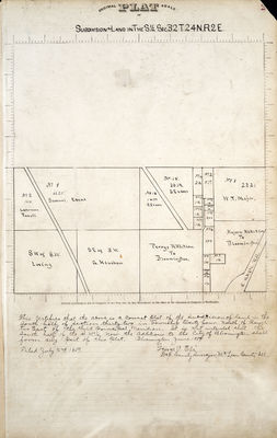
Subdivision of Land in the S1/2. Sec.32 T24N.R.2E
This certifies that the above is a correct plat of the subdivision of land in the south half of section thirty two in Township twenty four North of Range two East of the third principal meridian. It is not intended that the south half of the S.W.1/4 now the additions to the City Bloomington shall form any part of this plat. Bloomington June 1859 George P Ela Dep County Surveyor McLean County Ill.
PB01P203
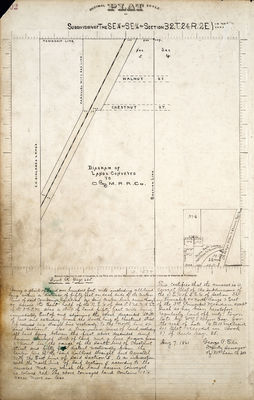
Subdivision of the SE 1/4 of SE 1/4 of Section 32.T.24.R.2E.} in the (corn?) Book R page 665 Being a strip of Land one hundred feet wide including all land lying within a distance of fifty feet on each side of the center line of said company's Railroad as said center line runs through or across the East half of the N.E. 1/4 of Sec. 5.T.23.N.R.2E of the 3rd P.M. Also a strip of land fifty feet wide lying immediately East of and adjoining the above described strip of land and extending from the South line of Chestnut Street (if extended in a straight line westwardly) to the north line of said Section 5. Also a triangular piece of land, including all land lying between the first above described and herein conveyed strip of land and a line drawn from a point in the range of the south line of Chestnut Street and fifty feet distant westwardly from the Center line of the said Railroad straight and parrallel with the East line of said Section 5, to an intersection with the north line of said Section 5, according to the annexed map in which the land herein conveyed is colored red. The above conveyed land contains 10 1/4 acres more or less.
This certifies that the annexed is a correct plat of the subdivisions of the S.E. 1/4 of S.E. 1/4 of Section 32 in Township 24 North range 2 East of the 3rd Principal Meridian, except such as has been heretofore regularly laid off into town lots by (Wm.?) T. Major Esq. for the area of Lots 6 to 10 inclusive see plat recorded in Book 37 of deeds page 85.
Aug 7, 1861
George P. Ela Deputy Surveyor of McLean Co Ill
PB01P204
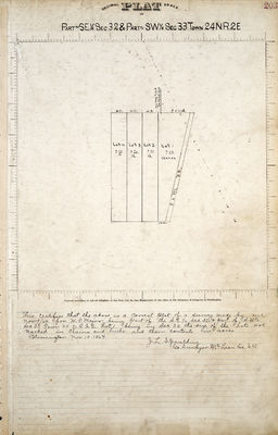
DECIMAL PLAT SCALE OF PART OF SE 1/4 SEC 32 & PART OF SW 1/4 SEC 33 TOWN 24 N.R.2E
Entered according to Act of Congress, in the Year 1871, by IRA MERCHANT, in the office of the Librarian of Congress at Washington.
This certifies that the above is a correct plat of a survey made by me Nov 9/64 for W.J. Major, being part of the S.E. 1/4 Sec 32 & part of S.W. 1/4 Sec 33 Town 24 N.R.2E Lot 1 being in Sec 33. The size of the Lots are marked in chains and links and their contents in acres. Bloomington Nov 10, 1864
J.L. Spaulding Geo Surveyor McLean Co, Ill