Pages
page_0001
I am looking forward to reading your Anthology of muscular Scots poetry.
March 30th 1925.
THE RESIDENCY, GANGTOK, SIKKIM, INDIA.
[No: Lord Cawdor. JAS]
[ST: I think this is from Colonel O'Connor after Resident of Gyantse but I am not certain]
My dear Mr. Buchan,
I am here stopping with Bailey; and I am at last writing to you to give you some account of last year's peregrinations.
We came through here just over a year ago and went up to Gyantse. From there we did a couple of marches up the Lhasa road and then bore North along the S. side of the Yamdrok Tso. We crossed the Ladahk range out of the Yamdrok basin and came down to Tsetang on the Tsangpo. Hence we marched down the Tsangpo following Bailey's route to Tsela Dzong. As a matter of fact we crossed the Ladahk range again by a different route to theirs. They crossed it on
page_0002
the right bank of the Tsangpo via Lhagyari Dzong; whilst we crossed to the left bank and went via Öega Dzong.
We made a base at Tsela Dzong for a few months whilst we did some survey work & plant hunting. In June we moved to a base at Tumbātse in the Rong valley. From here we investigated the Doshang La (which was crossed from the Abor Hills by Trenchard and Pemberton in 1913.) where we found a large number of rhododendrons and primulas. We also climbed the Nam La (16,500') which is the most easterly pass over the main range. It is very coarse going, since the pass is occupied by glaciers which are badly crevassed on the South side. It had never been crossed; though we got to the top we could not take transport over it in July on account of deep snow. We also investigated the passes from the Rong chu valley with the Tsangpo.
page_0003
II
In August we set off via Tongjuk and the Pasum Tso (Pasang on map) to try to reach the Salween near Shuiden Gompa. The weather was very coarse and hampered our survey work. On account of the map being 40 to 60 miles out in places and the whole lie of the country being most vague we took about 3 weeks to get to Atsa (Atcha) on the South Lhasa - Cina Road. As we were still 150 - 200 miles from the Salween we could had no time to go further, so returned to the Tsangpo via Gyamda and down the Gyamda river to Tsela Dzong. It was a disappointment not to get to the Salween, but we contrived to straighten out that bit of country considerably.
We spent the Autumn in the same places that we had spent the summer in, surveying and collecting seed. Owing to blizzards it was too risky to take coolies over the Nam La in November. Snow was very deep on the glaciers, and,
page_0004
though I managed to get to the top again to get a hypsometer reading, it was as much as I could do.
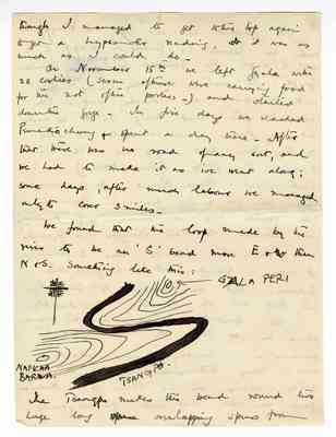
On November 15th we left Gyala with 28 coolies (several of these were carrying food for the rest of the porters.) and started down the gorge. In five days we reached Pemaköchung & spent a day there. After that there was no road of any sort, and we had to make it as we went along; some days, after much labour we managed only to cover 3 miles.
We found that the loop made by the river to be an 'S' bend more E & W than N & S. Something like this:
[sketch map showing GYALA PERI (north east) and NAMCHA BARWA (south west) on opposite sides of the TSANGPO river, with contour lines.]
The Tsangpo makes this bend round two huge long overlapping spurs from
page_0005
III
Namcha Barwa on the South and Gyla Pai on the North.
We got to Payül - after crossing the Namcha Barwa spur - in 11 days from Pemaköchung. From there we went up to Gompo Ne. We crossed the river below this point by a monkey bridge. There is no 'great turmoil of waters' where the Po - Tsangpo joins the Tsangpo. We went up the left bank of the Tsangpo above Gompo Ne and found a fall of about 40' - (a photograph of which I enclose) at the point at which we had to leave the Tsangpo to cross the spur to Payül. These were the only falls we saw. In places the river falls 200' - 250' per mile.