Pages
FL463764
[centred] CONTENTS OF MAP CASE
[centred] MAPS -
VIZ THREE MAPS AT EIGHT MILES TO AN INCH
________________________________________________
MAPS STITCHED IN WITH THIS VOLUME
FIFTEEN MAPS
__________________
DRAWINGS STITCHED IN WITH THIS VOLUME
THIRTY SEVEN DRAWINGS
_________________
PORTRAITS STITCHED IN WITH THIS VOLUME
PORTRAIT OF SIR THOMAS MITCHELL
______________
PORTRAIT OF Dr. LEICHHARDT
_____________________________
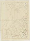
FL463765
[written beneath drawing of Condamine River] Scale of eight miles to an inch
[written to the right of drawing of Ballonne River]
Map of
Gwydir, Maranoa, and Fitz Roy Districts, with part of Darling Exhibiting the Stations occupied by the Settlers in these Districts, the Townships, principal lines of road, Mountains &c'a ... &c'a ... &c'a.
__________ By __________
William Gardner
Armadale
New England
_______________
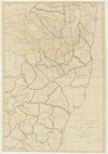
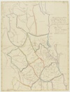
FL463769
[written on bottom-right of page, between Northumberland and Cumberland districts]
Map of
Northern and Western Districts
in New South Wales
Exhibiting the Townships & Stations occupied by the Settlers in the
Districts and Counties
_______ By ________
William Gardner
Armadale New England
_________ __________
FL463770
[top right] 2nd Vol NS [blurred latitude and longitude readings] 1834
[right of page, beside March district]
Map of the District of Moreton with part of Darling, Burnett, and Wide Bay. Exhibiting the Townships and the situation of the Stations occupied by the Settlers, principal lines of road &c &c
_______ By _______
William Gardner
Armadale New England
Scale eight miles to an inch

