Pages
1
RG 26 RECORDS OF THE U. S.
LETTERS RECEIVED BY THE LIGHTHOUSE SERVICE, 1829-1900
Official
April 1884- June 1884
Box 20 Entry 36
2
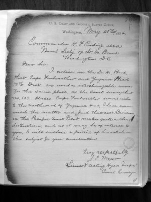
U. S. Coast and Geodetic Survey Office, Washington, May 28th, 1884
Commander H. F. Picking USN Naval Secty of Lt. Ho Board Washington D.C.
Dear Sir; I notice in the Lt. Ho. Book, that Cape Foulweather and Yaquina Head 13th Dist. an used as interchangeable names for the same place, as the Coast survey chart No. 603 places Cape Foulweather several miles to the northward of Yaquina Head, I have examined the matter and find that asst Davidson in the Pacific Coast Pilot makes quite a clear distinction, and as it may be of interest to you, I will enclose a portion of his article on this subject for your consideration
Very respectfully J. F. Moser Lisent ??? and Acting Hydro. Inspr Coast Survey
3
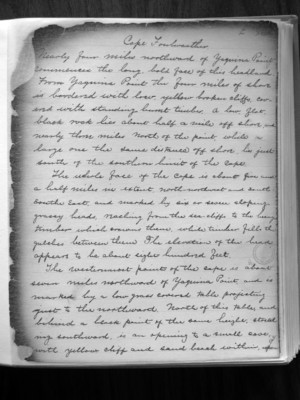
Cape Foulweather Nearly four miles northward of Yaquina Point commences the long, bold face of this headland. From Yaquina Point the four miles of shore is bordered with low, yellow broken cliffs, covered with standing burnt timber. A low flat black rock lies about half a mile off shore and nearly three miles north of the point, while a large one the same distance off shore, lies just south of the southern limit of the cape
The whole face of the Cape is about five and a half miles in extent, North-northwest and south-southeast, and marked by six or seven sloping grassy heads, reaching from the sea-cliffs to the heavy timber which growes there, while timber fills the gulches between them. The elevation of the head appears to be about eight Hundred feet.
The westernmost point of the cape is about seven miles northward of Yaquina Point, and is marked by a low grass covered table projecting just to the northward. North of this table, and behind a black point of the same height, stretching southward, is an opening to a small cave with yellow cliff and sand beach within, upon

4
which no surf was seen. It seemed probable that a boat landing could be safely effected there in ordinary northwest winds. This black point is marked by a dense cluster of woods.
The northern extremity of the cape is about nine and a half miles from Yaquina Point; thus??? northward the shore is comparatively low, and bordered by a sand beach. ++++