Pages That Mention Aids to Navigation Section
Coast Guard District narrative histories 1945
9
A monitor station was established at North Head Radio Station which checked the performance of all District Radio Beacons, and outlying stations were notified daily of all failures or defects in the radio beacons' operation. These reports were a District innovation and were not required by Headquarters but were merely another measure adopted by the District Coast Guard Office for increased efficiency in the District system. In March, 1944, Radio Station Meadowdale was ??? as a Monitoring Station for radio beacons, as the activities at that station had been considerably reduced. Although Headquarters' instructions ordered that each radio beacon in the United States be monitored at least once every four hours, it became possible in the 13th Naval District, to monitor each radio beacon every hour after the new monitor station had been added.
AIDS TO NAVIGATION IN UPPER COLUMBIA RIVER
In 1932 navigation in the Upper Columbia was revived for the transportation of wheat, but the servies between the Upper and Lower Ports was intermittent. This renewal of navigation was more or less on a trial basis to determine if sufficient commerce could be developed to support water carrier operation. Sufficient traffic was realized and, after the construction of the Bonneville Dam which was completed in 1938, river traffic expanded into the movement of great steel barges designed to carry liquid petroleum in the hull and package or bulk cargo on deck. With this increased traffic from Astoria, Oregon, beyond The Dalles, Oregon, the necessity of navigational aids to insure the mariner's safety became most apparent. As a result, the Aids to Navigation Section centered the majority of its activities in the promotion of safe navigation along the river. Here was the proving grounds for experimental light structures and buoys to determine those most suitable for the area. Due to the rapid current, range marking channels had to be so perfected as to enable the mariners to ascertain their course in a matter of seconds.
It was also necessary to experiment with range markings, and in this connection the Nautical Scientist in the Aide to Navigation Section, 13th Naval District, invented and constructed a system of laterally restricted range markings. This newly devised "Channel Limiting Group" was necessary because of the impossible terrain which made the establishment of the conventional markings impracticable if not impossible. With Headquarters' approval an experimental range was established on the Columbia River near Arlington, Oregon, which proved to be successful. Other experiments were concerned principally with surface riding buoys and fast water buoys.
-26-
13
units furnished the paint for camouflaging and structures. The last of the stations was returned to its normal peace time color by the end of the summer, 1945.
DISTRICT OFFICE PERSONNEL
Prior to, and for almost a year following the consolidation of the Lighthouse Service and the Coast Guard, the Aids to Navigation Section was administered by an Associate Mechanical Engineer with the assistance of two clerks and a stenographer. Both operational and engineering activities were combined in this section until the District was reorganized according to the Coast Guard organization plan. Engineering duties were then delegated to a separate Engineering Section and the operation and maintenance of aids to navigation became the responsibility of the Section. The Associate Mechanical Engineer, later promoted to Nautical Scientist, administered the department until the assignment of an Aids to Navigation Officer in 1944. Until that time, however the staff had increased to two Coast Guard Officers (R) (male) and one SPAR Officer, three enlisted Coast Guardsmen and six enlisted SPARS. In 1945, an Assistant Aids to Navigation Officer, trained especially in electronic aids was assigned to the section.
There was a little overlapping of activities between the Aids to Navigation Section and other departments, although its duties followed closely, in many instances, those of the Engineering Section, Vessel Operations, Port Security, Communications and Communications Engineering. These parallels were, respectively, in regards to surveying sites and deteraining??? structures, the movements of tenders, position of buoys and restricted areas, the monitoring of stations at North Head and Meadowdale and the activities of RACONS and the LORAN systems.
-30-
19
CONTENTS
I LIGHT STATIONS 1 II LIGHTSHIPS 14 III RADIOBEACONS 18 IV UPPER COLUMBIA RIVER 25 V BLACKOUT 39 VI ANRAC 45 VII SPECIAL BUOYS 51 VIII RACON-LORAN 56 IX LOCAL NOTICES TO MARINERS 68 X BUOY CARD FILE SYSTEM 69 XI TENDERS 75 XII STANDARDIZATION OF MINOR AIDS 80 XIII PERSONNEL OF AIDS TO NAVIGATION SECTION 83 XIV CHAPTER NOTES 1,11
45
at that time consisted mainly of the transportation of oil to inland ports and the movement of wheat downstream. Although the water was proven open to ocean-going vessels, the majority of the craft were tugboats and freight barges, especially the section above Celilo, Oregon. Several "oil tank farms" had been established along the shore to supply Army and Navy installations in that area and it was from these "farms" that the vast supply of oil and fuel came, so necessary in the Dupont project at Hanford, one of the plants that specialized in the manifacture of the Atomic Bomb. War gave emphasis to the river traffic and, subsequently, the Atomic Bomb. War gave emphasis to the river traffic and, subsequently, the Aids to Navigation Section of the Seattle District concentrated on lessening the danger and increasing the safety of those who plied the columbia.
50
the daymark to prevent their whole surface from being filmed with sand and dust. The Scotchlite was installed in other District Areas, mainly Coos Bay, with hearty approval of the mariners in the Bay.
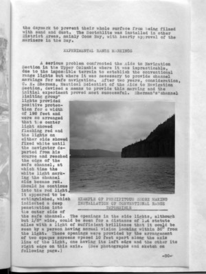
A serious problem confronted the Aids to Navigation Section in the Upper Columbia where it was impracticable, due to the impossible terrain to establish the conventional range lights but where it was necessary to provide channel markings for safe navigation. After two years, consideration, C. E. Sherman, Nautical Scientist of the Aids to Navigation Section, devised a means to provide this marking and the initial experiment proved most successful. Sherman's "channel limiting group" lights provided positive protection for a width of 198 feet and were so arranged that the center light showed flashing red and the lights on either side showed fixed white until the navigator departed from his course and reached the edge of the safe channel, at which time the white light marking the channel side became red. Should he continue into the red light, it appeared to be extinguished, which indicated a deep penetration into the outer side of the safe channel. The openings in the side lights, although but 1/8" wide, could be seen for a distance of 1.4 statute miles with a light of sufficient brilliance that it could be seen by a person having normal vision looking within 30° from the light. These openings were provided by the arrangement of two opaque screens spaced 10 feet apart along the axis line of the light, one having its left edge and the other its right edge on this axis. (See photographs and sketch on following page.)
(image) EXAMPLE OF PRECIPITOUS SHORE MAKING INSTALLATION OF CONVENTIONAL RANGE IMPOSSIBLE
-30-