Pages That Mention Aide to Navigation Section
Coast Guard District narrative histories 1945
9
A monitor station was established at North Head Radio Station which checked the performance of all District Radio Beacons, and outlying stations were notified daily of all failures or defects in the radio beacons' operation. These reports were a District innovation and were not required by Headquarters but were merely another measure adopted by the District Coast Guard Office for increased efficiency in the District system. In March, 1944, Radio Station Meadowdale was ??? as a Monitoring Station for radio beacons, as the activities at that station had been considerably reduced. Although Headquarters' instructions ordered that each radio beacon in the United States be monitored at least once every four hours, it became possible in the 13th Naval District, to monitor each radio beacon every hour after the new monitor station had been added.
AIDS TO NAVIGATION IN UPPER COLUMBIA RIVER
In 1932 navigation in the Upper Columbia was revived for the transportation of wheat, but the servies between the Upper and Lower Ports was intermittent. This renewal of navigation was more or less on a trial basis to determine if sufficient commerce could be developed to support water carrier operation. Sufficient traffic was realized and, after the construction of the Bonneville Dam which was completed in 1938, river traffic expanded into the movement of great steel barges designed to carry liquid petroleum in the hull and package or bulk cargo on deck. With this increased traffic from Astoria, Oregon, beyond The Dalles, Oregon, the necessity of navigational aids to insure the mariner's safety became most apparent. As a result, the Aids to Navigation Section centered the majority of its activities in the promotion of safe navigation along the river. Here was the proving grounds for experimental light structures and buoys to determine those most suitable for the area. Due to the rapid current, range marking channels had to be so perfected as to enable the mariners to ascertain their course in a matter of seconds.
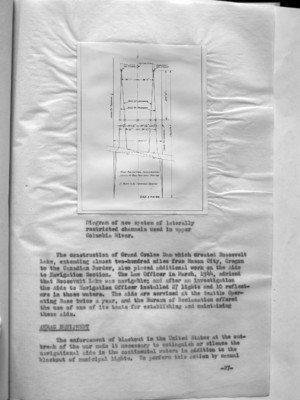
It was also necessary to experiment with range markings, and in this connection the Nautical Scientist in the Aide to Navigation Section, 13th Naval District, invented and constructed a system of laterally restricted range markings. This newly devised "Channel Limiting Group" was necessary because of the impossible terrain which made the establishment of the conventional markings impracticable if not impossible. With Headquarters' approval an experimental range was established on the Columbia River near Arlington, Oregon, which proved to be successful. Other experiments were concerned principally with surface riding buoys and fast water buoys.
-26-
10
(image)
Diagram of new system of laterally restricted channels used in upper Columbia River.
The construction of Grand Coulee Dam which created Roosevelt Lake, extending almost two-hundred miles from Mason City, Oregon to the Canadian Border, also placed additional work on the Aide to Navigation Section. The Law Officer in March, 1944, advised that Roosevelt Lake was navigable; and after an investigation the Aids to Navigation Officer installed 27 lights and 10 reflectors in those waters. The aids are serviced at the Seattle Operating Base twice a year, and the Bureau of Reclamation offered the use of one of its boats for establishing and maintaining these aids.
ANRAC ??? EQUIPMENT
The enforcement of blackout in the United States at the outbreak of the war made it necessary to extinguish or silence the navigational aids in the continental waters in addition to the blackout of municipal lights. To perform this action by manual
-27-