Pages
61
Blank No. 1.
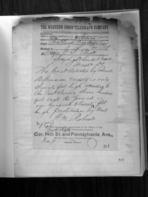
The Western Union Telegraph Company
The rules of this Company require that all messages received for transmission shall be written on the message blank of the Company, under and subject tot he conditions printed thereon, which conditions have been agreed to by the sender of the following message. Thos. T. Eckert, Gen'l Sup't William Orton, Pres't O.H. Palmer, Sec'y New York New York.
Dated: Portland Oreg Aug 25 1871 Received at: 1012 P To: Major G.B. Elliott
Secy Light House Board Washington DC
The point selected by Colonel Williamson & myself is only seventy feet high according to the Cost (sic - "coast") survey. Seven hundred feet east the ground is one hundred twenty feet high. Particulars by mail.
HM Robert 48 Cnt Genl Rate
This message just received at the Office of the Western Union Telegraph Company, Cor. 14th St. and Pennsylvania Ave., Where any reply should be sent. Direct wires.
304
63
(1 enclosure)
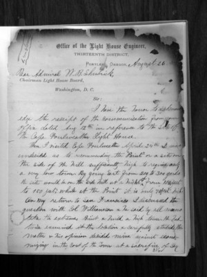
Office of the Light House Engineer Thirteenth District Portland, Oregon August 26, 1871
Rear Admiral W.B. Shubrick
Chairman Light House Board Washington, D.C.
Sir:
I have the honor to acknowledge the receipt of the communication from your office dated Aug. 12th in reference to the site of the Cape Foulweather Light House.
When I visited Cape Foulweather April 24th I was undecided as to recommending the "Point" or a site on the side of the hill sufficiently high to require only a very low tower. By going east from 200 to 300 yards the site would be on the side hill at a height of from 100 feet to 150 feet; while at the point it is only 70 feet high.
On my return to San Francisco I discussed the question with Col. Williamson and he said by all means take the extreme point and build a high tower. He had twice examined the location and carefully studied the matter and his opinion decided mine against economizing in the cost of the tower at a sacrifice of say
306
64
2
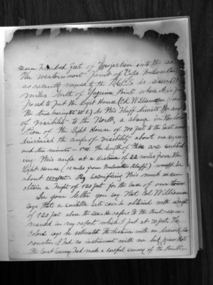
seven hundred feet of projection into the sea. The westernmost point of "Cape Foulweather" as recently named by the U.S.C.S. is seven (7) miles north of Yaquina Point where it is supposed to put the Light House (Col. Williamson gives the true bearing N 2 degrees 30' E.) As this bluff limits the angle of visibility to the North, a change in the location of the Light House of 700 feet to the East would diminish the angle of visibility about one degree and ten minutes - 1 degree 10'. The length of this arc subtending this angle at a distance of 22 miles from the Light House (15 miles from Foulweather Bluff) would be about 1500 feet. By sacrificing this much we can obtain a height of 120 feet for the base of our tower.
In your letter you say that Col Williamson says that a suitable site can be obtained with a height of 120 feet above the sea. He refers to the point recommended in my report which I put at 70 feet. The Colonel says he estimated the distance with an aneroid barometer. I had no instrument with me but knew that the coast survey had made a careful survey of the point in
307
65
(3)
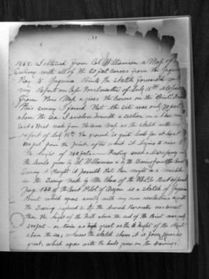
1868. I obtained from Col. Williamson a map of the survey with all of the 20 feet curves from the Yaquina Bay to Yaquina Point. The sketch forwarded with my report on Cape Foulweather of July 18th is copied from this map and gives the curves on the "Point". From this survey I found that the site was only 70 feet above the sea. I enclose herewith a section on a line near East and West made from the same map as the sketch with my report of July 18th. The ground is quite level for at least 500 feet from the point, after which it begins to rise to the height of 360 feet. Finding such a discrepancy in the levels given by Col. Williamson and by the tracing from the Coast Survey I thought it possible that there might be a mistake in the tracing made by Mr. Chase of the U.S.C.S. but opposite page 132 of the Coast Pilot of Oregon is a sketch of Yaquina Point which agrees exactly with my own recollections which the tracing referred to. If the aneroid barometer was correct the height of the hill above the end of the Point was only 240 feet - or twice as great as the height of the Point above the sea; whereas the sketch shows it is four times as great, which agrees with the levels given on the drawings.
308